Guide for Visiting Natural Bridges National Monument: Hiking + Things to Do
Natural Bridges National Monument is a hidden gem in the southeastern corner of Utah. This national monument was one of the first national monuments in the United States and the first National Park Service area in Utah – predating parks like Zions or Arches.
It protects 3 different natural bridges that have formed in a deep canyon which all have Native American names from tribes that lived in the region.
This beautiful monument is located in the middle of the wilderness, and features incredible landscapes, dark, starry skies, and of course, dramatic natural bridges. With the low number of visitors this monument gets, you can really enjoy the stunning views while escaping the crowds.
We were really delighted and surprised with our visit to Natural Bridges – delighted because the scenery was expansive and awe-inspiring, and surprised that more people don’t know about this incredible location!
We crisscrossed the park and did all the hikes and viewpoints – so in this post, we’re able to share a detailed description of everything to see and do in the monument.
No time to read now? Pin it to read later! ⬇️
This post may contain affiliate links. When you buy through these links, I may earn a small commission at no additional cost to you. These commissions help keep this site running. Thank you so much for your support!
Quick Tip: If you’re planning a Southwest US road trip, I recommend reserving a rental car ASAP for the best prices and availability. I always book my car with this rental car aggregate site to find the best deals.
What to See and Do in Natural Bridges National Monument
Natural Bridges is a relatively small park, with all the facilities and roads located along the top of a mesa, with deep canyons cutting into the landscape. There are 3 natural bridges in the park, and each one is located in the canyon. You can observe the bridges from the road, or hike down to stand underneath them.
Here is more detailed information about all the things to do in Natural Bridges.
1. The Scenic Drive

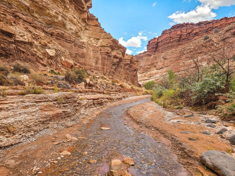
Officially known as the Bridge View Drive. the Scenic Drive is a one-way loop around the park that follows the ridge of a canyon where all the natural bridges are located. The canyon is full of rocky jutouts, and different rock walls and ledges and layers, creating a lot of movement and visual interest. Low desert bushes dot the landscape.
Everything to see and do in the park is located off of this loop. Note that the loop is a one-way road, so while you can skip stops, once you start you will drive the whole loop.

Towards the very end of the Scenic Loop, after you’ve visited Owachomo Bridge, keep your eyes open out the right side of the car for the Bears Ears – a set of twin peaks that has long been an important landmark in the region for Native Americans.
2. Sipapu Bridge
The Overlook

Sipapu Bridge Overlook is about a mile away from the trailhead, and offers an almost head-on look at the large, round natural bridge, which, despite its size, has a tendency to blend into the background!
This bridge is the biggest in the park, and is actually the second biggest natural bridge in the United States (after Rainbow Bridge in Glen Canyon).
The name Sipapu, a Hopi word, means a gateway or connection to the underworld, where souls can pass to the spirit world.
The Sipapu Bridge Trail
- Distance: 1.5 miles round trip (2.4 km)
- Elevation Change: 500 feet (152 m)
- Difficulty: Short, but steep
- Hiking Time: 45 min – 1 hour
The trailhead to Sipapu Bridge is about a mile down the road from the overlook. This is the steepest hike in the park, and you’ll drop 500 feet in less than 3/4 of a mile.
Despite the intensity, the Sipapu Bridge trail is a seriously fun hike. You’ll have some stretches just walking directly on the sandstone, with stones laid in a row to indicate the boundaries of the trail.

There are also a variety of steps – some carved directly into the stone, some wood or stone staircases, and also two metal staircases. You’ll also get to descend ladders and walk along cliffs and under overhangs, with great views of the bridge throughout the hike down.

About halfway through the trail, there is a short ( 5 min round trip) detour to a mid-level view of the bridge, with a sign clearly marking this short spur. From that turn off the trail becomes steeper and has more switchbacks.

The whole trail is pretty steep, but didn’t feel unmanageable. The stairs make the steepness much easier (especially descending).
The end of the trail brings you to an oak grove right under the bridge, with a stunning view of the towering bridge.

Late afternoon is particularly nice with the bridge glowing from the western sun and plenty of shade on the trail.
3. Horse Collar Ruin Overlook

- Distance: 0.6 miles round trip (1 km)
- Elevation Change: 30 feet (9 m)
- Difficulty: Easy
- Hiking Time: 20 minutes
This is a short and easy hike to an overlook of some cliff dwelling ruins located in the crevices of the canyon walls. These dwellings are part of a well- preserved, historic Pueblo Native American village from AD 1050-1300.
The actual structures and buildings are located toward the bottom of the canyon wall. In the picture above, they are in the little arched openings just above the treeline.

One important structure in Native American cliff dwellings are the kivas, which are ceremonial rooms used for religious or political meetings.
The dwellings in Natural Bridges are particularly interesting because the dwellings have both square and round kivas. The round kivas are from the Mesa Verde region, and the square ones are from the northern Arizona Kayenta region.

While Mesa Verde National Park has some of the highest concentrations and most famous cliff dwellings in the southwest, there are actually dwellings like these scattered all over the southeastern corner of Utah as well.
4. Kachina Bridge
The Overlook

Next up along the Scenic Drive is Kachina Bridge. This is the youngest and thickest bridge in the national monument. From above, the bridge almost appears like a half-bridge, with one side ending higher up on the rock wall.
The bridge is named for the Kachina dancers, which are an important part of Hopi religious traditions.
Kachina Bridge Trail
- Distance: 1.5 miles round trip (2.4 km)
- Elevation Change: 400 feet (122 m)
- Difficulty: It’s short, but steep!
- Hiking Time: 45 minutes – 1 hour

The Kachina Bridge trail starts at the same place as the overlook, and is another extremely fun yet extremely steep trail down to the base of the bridge.
You’ll descend multiple stone staircases carved in the rock, little sections of trail along the side of the cliff, and descend a steep face of slickrock by holding onto a pole and then climbing down a ladder. The adventure factor is high!

Once you reach the bottom of the canyon, the valley is rather green and lush, with trees and shrubs filling the sandy wash where a river occasionally runs during high rainfall. The bridge looms grandly over you, and you can walk underneath to the opposite side for an alternate view.

5. Owachomo Bridge

Owachomo Bridge Viewpoint
The Owachomo Bridge Viewpoint is right at the beginning of the trail down to the bridge. The bridge almost blends into the background from this vantage point! Owachomo means “rock mound” in Hopi.
Owachomo Bridge Trail
- Distance: 0.5 miles round trip (0.8 km)
- Elevation Change: 180 feet (55 m)
- Difficulty: Moderately easy
- Hiking Time: 30 minutes

This is by far the easiest and shortest hike in the park. The hike down is over uneven rocks, and though short, still has some decently steep sections. The view at the bottom is incredible, and there are several good vantage points along the way.
6. Loop Route

- Distance: 9.8 miles (15.7 km) if you do the entire loop trail. Alternatively, you can just hike between two bridges for a shorter distances (5-6 miles)
- Elevation Change: 500 feet (152 m)
- Difficulty: Strenuous
- Hiking Time: 6 hours
Another option for seeing all the bridges is hiking the loop trail that connects all three bridges (as opposed to driving to the trailheads between the bridges). There is one long trail at the bottom of the canyon that follows the wash and creates a loop through the canyons.
This loop also goes just underneath Horsecollar Ruins, although to be honest, the view from below is not great. The view from the overlook is actually much better than from below.
The Loop Trail is unmaintained and can be difficult to follow at times, so it’s highly recommended to have a trail map on your phone (I highly recommend All Trails Pro and downloading the trail map for offline use).
Helpful Information
✔️Hours and Entrance Fees
Natural Bridges National Monument is open all day, year round.
It costs $20 for a private vehicle to enter Natural Bridges (good for 7 days), or you can use your National Parks Pass to get in free.
✔️The Visitor Center
The visitor center has an outdoor water fountain and bottle refill station, and nice, air-conditioned restrooms that are open 24/7. It’s open from 9am-4pm, and closed from 12-1pm.
✔️Junior Ranger Activities

As part of the national park system, Natural Bridges has a Junior Ranger program. If you’re traveling with kids between the ages of 5-12, you’ll definitely want to stop at the Visitor Center to pick up a booklet.
Kids need to complete a certain number of activities in the booklet that are all centered around Natural Bridges National Monument, and then turn the booklet back in to receive a cute wooden badge. My kids love this program!
✔️Safety Considerations
- Make sure you bring plenty of water with you when hiking – the trails are exposed and the heat is intense and dry in the summertime.
- During lightning storms, stay away from lone trees, cliff edges, and high ridges.
- Flash floods can occur and are dangerous. If there is rain in the forecast in the region, check with the rangers at the Visitor Center to assess if you can safely hike down to the bridges.
- Do not climb on the bridges – it’s not safe for you or for the bridges
✔️Leave No Trace

Make sure you pack out everything you bring and stay on the trails. Desert landscapes are sensitive and rely on an extremely slow-growth symbiosis called biological soil crust.
The dark, lumpy sand in the picture above is formed from special organisms living in the crust that create a special soil that is much better at retaining moisture allowing plants to grow in harsh conditions. Stepping on it destroys this crust and greatly increases erosion.
The crust can take decades to recover, so please stay on the trail.
✔️What’s the Difference Between Natural Bridges and Arches?
Arches and Natural Bridges look very similar, but the way they are formed is somewhat different. Bridges form from flowing water cutting through the rock and making an opening. Arches form as rock walls erode (think the freeze/thaw cycle) leaving a hole in them.
✔️Are Dogs Allowed?
Dogs are allowed on roads and paved trails only (including to the viewpoints) but not the hikes down into the canyon.
✔️How Long Do You Need?
You can easily see the 4 viewpoints and hike down to the 3 bridges, drive the Scenic Drive, and make a stop at the Visitor’s Center in half a day. We did the entire park in about 3 hours (but we were hustling).
If you decide to do the entire Loop Trail that connects the 3 bridges, plan for a full day in the park.
If you’re short on time, you could choose between the Sipapu Bridge and the Kachina Bridge hikes, as they have a lot of similarities. Both are great hikes, but I would probably go for the Sipapu Bridge hike first, as it’s the oldest and biggest natural bridge.
Alternatively, if you just want to see the bridges from the viewpoints, you can probably see everything in about an hour.
Camping at Natural Bridges

There is a first come, first serve campground in Natural Bridges with 13 sites and vault toilets. There is no electricity, running water, or showers in the campground. The sites are very nice, with large sandy platforms for tents, picnic tables, and other clear areas.
The campground isn’t a particularly popular one, so it’s rarely full, even during the summer. Campsites cost $16 per night.
Conclusion – Is Natural Bridges Worth Visiting?
Natural Bridges is a great stop as you are exploring southern Utah. We loved our time here, and think its definitely an underrated gem in the American Southwest. I’d definitely consider adding it to your itinerary to the southeastern corner of Utah.
Nearby, you can visit Monument Valley and Valley of the Gods, or make a stop at Four Corners National Monument.
About 2 hours to the east is Mesa Verde National Park, and you can observe and tour the cliff dwellings (similar to the Horsecollar Ruins in Natural Bridges, but much, much bigger) that dot the park landscape.
To the west, you can continue through southern Utah and Arizona, visiting Lake Powell, going hiking around Page, Arizona, or visiting Zion National Park, Bryce Canyon National Park, and the Grand Canyon.
There’s a lot to visit in this part of the country, and Natural Bridges National Monument is definitely an incredible spot!


![A Guide for Hiking Lower Calf Creek Falls [Utah]](https://usadventurer.com/wp-content/uploads/2023/08/lower-calf-creek-falls-utah.jpg)