20 Jaw-Dropping Things to Do in Valley of Fire State Park
Looking for the best things to do in Valley of Fire State Park? You’re in the right place – read on for details!

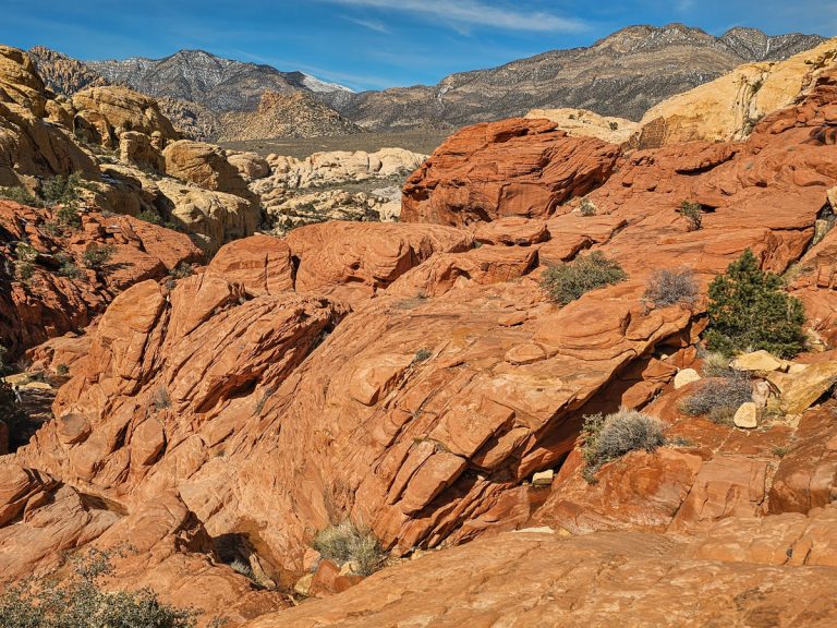
I’ve traveled all over southern Utah, Arizona, and Nevada, but Valley of Fire is truly one of the most stunning, jaw-dropping places I’ve visited in the southwest United States. As you are driving in from Las Vegas, you’re going through barren, scrubby land with tan-gray, non-descript hills and mountains around you.
Then, you turn a corner and BAM! The deep red-orange, craggy sandstone rocks of Valley of Fire suddenly and dramatically appear, a stark contrast to the surroudning scenery.
There are tons of fun things to see in Valley of Fire! In addition to the fiery red rocks, you’ll see petroglyphs, slot canyons, overlooks, and incredible multi-colored striations in the rocks.
Many people don’t realize that between the glitzy Las Vegas and the epic national parks of Utah and Arizona is this often underrated and overlooked Nevada State Park.
Valley of Fire is easily done as a day trip from Las Vegas, or as part of a larger southwest, southern Utah or northern Arizona road trip. It also works well if you’re roading down to places in southern California, like San Diego, or heading north up to Cathedral Gorge State Park.
It’s DEFINITELY worth taking a day to visit this stunning state park, so let’s talk about the best things to do in Valley of Fire!

How to Get to Valley of Fire: The easiest way to get to Valley of Fire is to pick up a rental car and drive yourself. I always book my car with this rental car aggregate site to find the best deals.
Alternatively, you can book this highly rated Hiking Tour of Valley of Fire, which provides transportation to and around the park and guides to some of the fantastic trails.
20 Best Things to Do in Valley of Fire
The main part of this post is divided up into 3 different sections: Best Hikes, Best Rock Viewpoints, and Animals. At the very end of this post, you can find a Practical Information section full of helpful tips and info about visiting the park.
Remember, always Leave No Trace when going out into nature. Besides not littering, packing out any trash you may have, and not approaching animals, this also includes not carving into rocks or touching the petroglyphs! Please help keep this beautiful park pristine and in great condition!
Best Hikes in Valley of Fire
The best things to do in Valley of Fire involve hiking! The following 7 trails are ones to all consider when you visit the park.
1. Rainbow Vista Trail

Rainbow Vista Trail is an easy hike that starts out in an open section with scrubby plants around before going in to a little canyon area with sloped, red-rock walls that look like rocks have just been heaped up on either side. It creates a delightfully haphazard feel as you walk along a sandy wash.

The trail ends at the Fire Canyon Overlook, a large canyon filled with rocks and formations in a huge variety of shapes and sizes. There are a few big boulders you can climb up to see the canyon from a higher vantage point.
Trail Stats:
- Distance: 1.1 miles
- Elevation Gain: 95 feet
- Difficulty: Easy
2. White Domes Trail

White Domes is the farthest back trail in Valley of Fire State Park. It’s named for the big, round, light colored rocks at the beginning of the trail (you can see them in the back of the photo, above).
This trail is fun for a few reasons. Beyond the namesake domes, you’ll also see more multi-colored rocks and even some striated rocks throughout the trail. Some rocks even had a purple tint to them!
Also, this hike takes you down through a little canyon area, including a small section of tight, slot canyon!

The slot part is short, but it is still very cool and adds a nice “flavor” to the hike.
Trail Stats:
- Distance: 1.1 miles
- Elevation Gain: 177 feet
- Difficulty: Easy
3. Mouse’s Tank to Petroglyph Canyon Trail

Mouse Tank Trail is very similar to Rainbow Vista Trail, in that it goes through a small-ish canyon area with craggy rocks rising up on the side of you. What makes Mouse’s Tank Trail unique are all the petroglyphs that you can see on the rocks!
There are over 800 petroglyphs on this trail, and it’s actually the largest collection of petroglyphs in the state of Nevada! Look for the dark spots on rocks – that’s where you can see most of them (the black is algae put there by the Pueblo Indians). Remember, don’t touch the petroglyphs! (it’s hard to get to them anyway)

The rest of the trail has great views, with dark red rocks on both sides of the trail. While the trail ends at another overlook, the view here isn’t nearly as good as Rainbow Vista. Still, it’s worth doing this hike for the petroglyphs and the trail itself.
Trail Stats:
- Distance: 0.8 miles
- Elevation Gain: 55 feet
- Difficulty: Easy
4. Fire Wave Trail
The #1 thing you cannot miss in Valley of Fire is the Fire Wave formation. Accessible from the Fire Wave Trail, this spot is the “crown jewel,” so to speak, of Valley of Fire State Park.
The Fire Wave rock formation, is absolutely incredible, with bands of red, light pink, orange, and cream swirling around each other. And while the Fire Wave is the most stunning part, the entire area around the Fire Wave is filled with beautiful formations of multi-colored rocks.

Make sure that you wander around and explore the whole rocky area to really see and appreciate the amazing colors in the rocks!
If you can swing it, the Fire Wave is best visited right before sunrise – the colors actually get a little washed out when the sun hits it. But it’s still beautiful no matter what time of day you get there!

One very important thing to note is that the Fire Wave is generally closed during the summer due to extreme heat. Park rangers told me that they see the most injuries and health crises at this location during the summer. Closures do depend on weather (if it happens to be a cooler period, the Fire Wave may be open), but if you want to see this rock formation, plan to visit during the fall, winter, or spring.
About 20 minutes after sunrise, the light hits the Fire Wave. It’s still beautiful of course, but you can see how there is some glare on the rocks.
Trail Stats:
- Distance: 1.5 miles
- Elevation Gain: 236 feet
- Difficulty: Easy
5. Fire Wave + Seven Wonders Loop
If you want to do a shorter hike, you can definitely just do an out-and-back hike to the Fire Wave and call it good. However, if you want to continue and see Pastel Canyon and other parts of the park, then instead of turning around at the Fire Wave, you’ll continue on and do the Seven Wonders Loop.

This loop takes you through Pastel Canyon, crosses Mouse’s Tank Road, and continues the trail on the other side of the park.
Pastel Canyon is a short yet beautiful little slot canyon, with short walls and rock walls with lightly colored pinks, purples, and creams. You’ll see striations in the rocks here, similar to at the Fire Wave. This little canyon is one of our favorite parts of the park!
The scenery throughout the whole loop is really beautiful, as you get several more spots with striated rocks, little pathways through small canyons, and vistas overlooking the incredible landscape.

In summer, while the Fire Wave is closed, you can still hike the rest of the Seven Wonders loop.
Note: You used to be able to park on the side of the road and hike Pastel Canyon to the Fire Wave; however, this parking spot is now closed off. The Seven Wonders Loop is a relatively new trail in the park, and since they turned the Pastel Canyon section into part of the loop, they no longer want people parking on the side of the road, where hikers are now crossing.
Trail Stats:
- Distance: 2.3 miles
- Elevation Gain: 209 feet
- Difficulty: Easy
6. Elephant Rock Loop Trail

Elephant Rock Trail is located on the very eastern entrance to the park (the entrance you you use when coming from the north). Park by the fee station pullout, and then start walking on the (not super well-marked) trail that follows the road heading west.
After about 100 yards, you’ll walk by a mound of rocks on your right. Here you’ll find Elephant Rock!
Beyond Elephant Rock, the trail becomes very well-marked and easy to follow and takes you around the mound of rocks. These rocks have a lot of little holes and pocked out caves in them, from sediment erosion, giving the area a unique appearance.

Trail Stats:
- Distance: 1.3 miles
- Elevation Gain: 173 feet
- Difficulty: Easy
7. Pinnacles Trail

Pinnacles Trail is a bit of a hidden gem hike in Valley of Fire. It doesn’t appear on any park maps, but it is on AllTrails, and when I talked to a ranger about it, she told me it is an unofficial trail, and not maintained by the park.
You’ll hike for about 2 miles through the scrubby and barren desert landscape, until you see some of Valley of Fire’s characteristic round orange boulders rising up in the distance. That’s the Pinnacles section!
This area is absolutely gorgeous, with tall, spire-like rocks and plenty of places to scramble around and play. If you hike straight through, this section only lasts for about 0.5 miles, but it’s spectacular.
Overall, Pinnacles is a long walk for just a short cool section, but dang the Pinnacles section is pretty. If you want to see some BEAUTIFUL rocks with no one else around, this is a great trail for you.
Trail Stats:
- Distance: 4.8 miles
- Elevation Gain: 429 feet
- Difficulty: Medium
8. Drive Mouse’s Tank Road

Mouse’s Tank Road is the unofficial name for White Domes Road, one of the two main roads in Valley of Fire. It’s 5.5 miles long, and goes from the Visitor’s Center to the very back of the park. Most of the hikes are off of this road, including the first four hikes at the top of this list.
This road is truly stunning – tall piles of rounded red boulders are heaped up on top of each other, and the road has slight undulations as it winds through the rocks. The views from the road are unmatched and an attraction in its own right.
There are several unofficial pull off spots along this road to admire the scenery, and getting a photo-op of this road is a popular activity in Valley of Fire.
Rock Viewpoints
Besides hiking, the other main thing to do at Valley of Fire is see the different rock features around the park. Many of these locations also have picnic tables and restrooms, so make for a good place for a midday lunch break.
9. Mouse’s Tank Road Viewpoint

Besides the Fire Wave, this viewpoint is one of the most photographed spots in Valley of Fire State Park. This viewpoint is right before the parking lot for Rainbow Vista Trail, and is actually labeled on Google Maps as “Mouse’s Tank Road Photo Location.”
There’s a big rock you can climb for a great view and picture over the road!

10. Elephant Arch
I talked about Elephant Rock in the Hikes section, but it’s worth including in this section to say that many people just choose to just go look at Elephant Arch, and not do the entire 1 mile loop hike. If you do this, it’s a short walk to the arch, which you can see from the side of the road.
11. Historic Cabins

These cabins were constructed during the early days of the park for visitors to rest and shelter in. They are nestled up against the mountainside, and have a little fireplace inside each cabin – they’re kind of cute!
There are bathrooms and picnic tables here as well.
12. Lone Rock

Lone Rock is pretty aptly named – it’s literally one large rock sitting by itself, apart from the mountainside. There’s a few hollowed out places in the rock you can climb into. Personally, I didn’t think this was a particularly interesting spot – if you’re short on time, I’d just skip it.
13. Petrified Log

At the top of a set of stairs built into the cliffside is this old, petrified log, encased in fencing. This extremely old tree trunk has some pretty colors in it and is now rock. Personally, I found this one to also be less interesting – if you’re short on time, I’d say you could skip it.
14. Seven Sisters

This viewpoint has seven free-standing, tall boulders that are all in a line. It’s kind of cool to see as the boulders together create a cool effect, and you can walk around and explore. There aren’t bathrooms here, but there are picnic tables.
15. Balance Rock

Balance Rock is right by the Visitor’s Center and the start of Mouse’s Tank Road. After a very short walk, you’ll see this boulder, which balances impossibly on a small tower of rocks. The best views of it are from the back – continue walking the trail to the backside for this perspective.
There are bathrooms and picnic tables by the Visitor’s Center.
16. Atlatl Rock

I was expecting Atlatl Rock to be a rock shaped like an atlatl (a type of stick used by Native Americans to propel and throw a spear farther). However, this rock actually features petroglyphs, which include petroglyphs of an atlatl. You’ll walk up the staircase to see the petroglyphs carved high up on the boulder.
The atlatl glyph is located at the top of the petroglyphs.

17. Arch Rock

Arch Rock just has a little pull-off section on the side of the road – no dedicated parking lot. Walk around the backside of the rock to see the arch suddenly peak out at the top! The park does ask that you don’t climb on Arch Rock.
18. Beehives Rock Formations

The Beehives area is a particularly fun viewpoint/area to explore that is very close to the West Entrance (the one nearer Las Vegas). There are several rock formations of stacked, layered sandstone that really resemble beehives. Plus, you can explore the hills and nooks around the area.
Other Things to Do in Valley of Fire
19. Spot Wildlife


There are several types of mammals that you may see at Valley of Fire, including bighorn sheep, jackrabbits, and even coyotes or foxes. Other animals you may see include lizards and iguanas, rattlesnakes, desert tortoises, and many varieties of birds.
20. Go Camping

Valley of Fire has two first-come, first-serve campgrounds: Atlatl Campground, and Arch Rock Campground. There are 72 campsites between these two campgrounds.
Atlatl Campground is bigger, and has some wifi availability, as well as more modern facilities, and RV hookups. Arch Rock Campground has fewer spaces, no wifi, and only vault toilets. The Arch Rock Campground is also closed during the summer months.
Both campgrounds are very beautiful, set among the rocks as background. Camping costs $20/night, with an extra $10 if you want to do RV hookups.
There are also group use campgrounds that you can reserve ahead of time.
Practical Information for Visiting Valley of Fire State Park
How Much Time Do You Need in Valley of Fire?
You can definitely see and do a ton of things with just a few hours in the park. With an entire day, you can do all the hikes and see all the viewpoints.
Only Have a Few Hours? Here’s What I Would Prioritize:
If you only have a short amount of time for Valley of Fire, here’s what I would do. All of this can easily be done in 4-5 hours of time (or less, if you’re fast):
- Start by hiking the Fire Wave. This is the most epic hike in the park, you can’t miss it.
- Keep going beyond the Fire Wave to Pastel Slot Canyon. At the road, you can keep going on the loop, or turn back and come back the way you came (they are about the same distance)
- Do the White Domes hike. The slot canyon here is very fun!
- Hike either the Mouse’s Tank Trail or the Rainbow Vista Trail. The overlook is better at Rainbow Vista, but Mouse’s Tank has petroglyphs. The trails themselves are very similar.
- Stop at the Mouse’s Tank Road Viewpoint for a photo op.
- Stop by Arch Rock, Atlatl Rock, and the Beehives. Elephant Rock would be my next choice if you have time for it.
Alternatively, Consider this Guided Tour to Valley of Fire from Las Vegas
This highly rated Hiking Tour of Valley of Fire, you can choose from an easy hike, medium hike, or difficult hike, spending anywhere between 2-4 hours hiking in the park. No matter which hike you choose, you’ll see beautiful rock formations and hear interesting facts about the park as you explore! Round trip transportation from Las Vegas is included.
Check availability and rates for this guided tour here
Entrance Hours and Fees
Hours: The park is open from sunrise to sunset. Outside of these hours, you must be out of the park or in one of the campgrounds.
Entrance Fees: $15 per vehicle for out-of-state vehicles, $10 per vehicle for Nevada residents.
Pets
Pets are allowed in the park, but they must be on a leash under 6 ft long.
How to Get to Valley of Fire
Valley of Fire is approximately an hour from the Las Vegas Strip, and is extremely easy to get to. Just hop on I-15 North, and get off at exit 75 for Valley of Fire/Lake Mead. Then, just follow the road straight into the park – easy peasy!
Best Time to Visit Valley of Fire
Fall, winter, and spring are definitely the best times to visit Valley of Fire. In fact, it is HIGHLY recommended to NOT visit in summer, as temperatures can get up to 120 degrees F. If you do visit in summer, I would recommend hiking right at sunrise, and bringing plenty of water. A water fill-up spigot is available on the west side of the Visitor’s Center.

Where to Stay Near Valley of Fire
If you don’t want to camp in the campgrounds at Valley of Fire (or if they are full), here are some other options:
Dispersed Camping
There is dispersed camping available on BLM land just outside the park. Dispersed camping is free, but there are absolutely no facilities and you must pack out everything that you bring in (including waste). You can find these camping areas on Highway 169, outside the eastern entrance of the park. Search for “Poverty Flats Camping” or “Snowbird Mesa” to find these sites.
Nearby Hotels
If you aren’t into camping, you can stay in Las Vegas, in Lake Mead, in the nearby city of Moapa Valley, or in Mesquite, Nevada (north of Valley of Fire, off of I-15).
The closest hotel to Valley of Fire is the North Shore Inn at Lake Mead in Moapa Valley.
Cell Service
There is essentially no cell service in Valley of Fire. I’ve randomly gotten it for a minute at the Fire Wave parking lot, and at the top of Atlatl Rock, but basically no other service anywhere in the park.
Pro Tip: I would highly recommend you download offline maps before you go so you can navigate without cell service.
A Guide to Visiting Valley of Fire – The Wrap Up
Valley of Fire is a must visit location for anyone in the Vegas, southern Utah, Grand Canyon, and Northern Arizona regions. The vibrant, fiery rocks of this state park can truly hold their own with any location in the southwest!
Planning a Southwest Road Trip? Check Out These Other Posts:
- Visiting Bryce Canyon National Park with Kids – Your Detailed Guide
- How to Hike Peekaboo and Spooky Gulch Slot Canyons
- The Ultimate Guide to Hiking in Arches National Park